I read an article about Google Maps last year on ProPakistani. Recently I used the latest version 3.0 of Google maps for mobiles phones. It has come with the new improved additions which consist of many cool features like, Google Latitude, Street Views, and Map Views etc.
In Pakistan a common man has no access to Satellite GPS based system but Google’s Innovation has changed all that, now a person in Pakistan can use Google Maps and have a taste of Assisted GPS (A-GPS). Google Maps supports GPS enabled phones, especially
- Blackberry
- Windows Mobile
- Symbian S60
- Java
- Palm
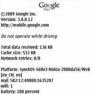
Google Maps on a phone can: – (As Described on Official Google Web Site)
- Determine your current location with or without GPS
- Get driving and transit directions
- Get phone numbers and addresses for local businesses
Version 3.0 Consists of Following Improvements:
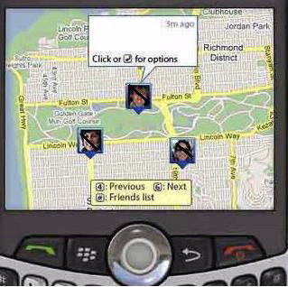
Google Latitude is recently added in this version and its has following features
- User can sign in with his/her Google account and can add friends
- Can see the friends location in a real time
- Can set his/her own location manually
How to install Google Maps
Please note that Google Maps is a data hungry software, so make sure that you have Unlimited GPRS package or otherwise you are ready to pay heavy for this.
We assume that your mobile phone is GPRS enable and activated, simply point your net browser on mobile phone to this url : m.google.com/maps
Download the application and install it. You are done, simple open Google Maps (by going into application folder)
What Pakistani Users can see and Experience with Google Maps on their Mobile Phones
For Pakistan the scenario is different here we can find the location In a real time view but, the traffic directions and addresses are missing most of the times, so one must be familiar with the real time image of a location so that we can identify that where we are exactly.
Mostly images (maps) of most of the Pakistani Cities and Places are outdates, as they were taken back in 2003, and one may feel some differences now in the maps.
However, major cities’ maps are updates while, Karachi is the Most Updated city of Pakistan in the Google Maps.
We can edit and add locations and roads in the Google Maps now, but still it will take long time or an extra ordinary effort by volunteers to edit or add locations in the Pakistani Maps. Some how Many Big Cities of Pakistan has Street Addresses and directions which is a good sign.
Below is what you can see and experience on your Mobile Phone.
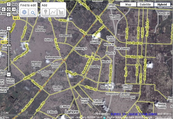
This is a view of Lahore in Map Add/Edit option of Google (Many Users are adding Places day by day)
A blue Spot identifies the location of the user
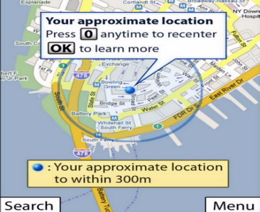
How Google Maps Works for Pakistani Users
The technique that Google uses to work out location is actually the same one that any GPS device uses: triangulation.
How it works: When Latitude turns on, it automatically tries to reach any available GPS satellite, cell tower or Wi-Fi access point (AP). Once it establishes three or more links, it starts working out location.
Google has a database of CELL Towers in Pakistan and with the help of cell towers it identifies the location of the user in a real time, approximately location is sometimes accurate to about 10 to 20 meters and sometimes up to 3000 to 4000 meters, depending upon the cell tower data it is using. Together, these tens of millions of fixed locations give Latitude the grid it needs to work out your location.
The position is approximately to accurate in cities in Pakistan due to the usage of multiple Cell Towers, and on Highways it may be in a range of 3000 to 4000 meters due to less number of towers available.
If our mobile device is using multiple cell towers, you can get accuracy of 100-meter circle. While in rural areas with less towers around, you may find 3000 meters accuracy or even more.
Many variables can interfere with our accuracy, however. Unfortunately, there are no hard and fast rules on determining how accurate Latitude or any other Latitude Base System application will be at any given location. The devices can use up to 24 reference points to work out the location.
The mobile device doesn’t have the CPU horsepower to work that out. It takes the raw data and transmits it via a GSM, GPRS to an assistance server. This technique is called A-GPS (assisted GPS). Your mobile device works together with the server to plot out your location.
And this is the important part for Latitude: Since the assistance server has the results of the calculation, it’s easy to share your position with anyone else that uses Latitude and has your permission to see your location.







Doodle does NOT have a database of the cell tower locations in Pakistan. no one has that database except for FAB and PTA.
this thing works by just triangulating your position from th network signals being received in any area. This means there is not need for a database.
And the local maps for pakistan you are referring to….they are currently NOT available on google maps. these maps are being prepared by community effort on Google Map Maker. In due time ys they will become available on mobile maps as well as google maps.
So if I leave my cell phone (hide it in the car) that phone can help me locate my car real time? if this the case I think car tracking companies will be out of business pretty soon
hah … leaving cell phone in car with GPRS is more expensive than having a car tracking system.
Thanks for correcting me
The question was: How does Google know My location in Pakistan?
There are Two types of local information needed:
1-The tower location data
2-The map data.
There are companies which sell such kind of data so expect this feature to be available at more and more places. Rest of the algorithm uses the signal information and the application is able to locate you within a certain degree of accuracy.
Wireless phones can make and receive calls because they are connected over the air to a nearby cell tower. The phone knows the ID of the cell tower that it’s currently using. If the phone has GPS, the Maps application on the phone sends the GPS coordinates along with the cell ID to the Google location server. Over millions of such updates, across multiple phones, carriers, and times, the server clusters the GPS updates corresponding to a particular cell ID to find their rough center. So when a phone without GPS needs its own location, the application on the phone queries the Google location server with the cell tower ID to translate that into a geographic location, i.e., lat/long
Flow Sheet : http://1.bp.blogspot.com/_pcoA74Ez-Ks/SEm0YvI_BCI/AAAAAAAAAHo/G9X8VLwsC34/s400/MyLocation.png
with Latitude the application from google..potentially you can since u can use the internet to track ur phone
other wise there is no way for you to see the location of your phone. so without latitude it wont be possible.
very well :D
Does it work only on GPS enabled phones??
Nice article but the statement that Google has data of all the mobile towers is not correct. Google collects the serving cell information from all the google maps users. this is written in the privacy policy of the software or somewhere. Now if the phone using google maps also has GPS then when that phone uses both GPS and google maps, Google server collects the signal strenght, the cell ID and the actual GPS coordinates of that location. This data after processing and application of algorithms is then used to locate Non GPS enabled phones.
@Ahsan, Yes it works for non gps phones but the accuracy as stated in the article varies depending upon the data available in google servers for that area/ cell IDs.
The screenshot of Lahore above is from Google MapMaker – not Google Maps. That means in Google’s Map application on cellphones, you’ll only see satellite imagery since the streets/points data has not yet been ‘officially’ made part of their Maps data.
Well its very nice but my question is that …..Do Google server have info about all Mobilink BTS (Lat/Long)?
i just opened Lahore,its not routable all i see is a yellow road named 70,dubai and newyork open fine
can i use it on Sony Ericsson P910i?
Yes Tipu u may use it. because i use on Sony Ericsson K550i
will you please guide me how can i use it …..do i need to install software for it ….
yes u shoud be install siftware
Hello:
I have a 2006 Toyota Reconditioned Corolla in Karachi / Pakistan. GPS system and Screen is installed but I need an appropriate Software to be uploaded to enable Pakistan Cities (especially / particular for Karachi).
Can some help me provide latest / updated software with its installation assistance in Karachi.
Regards
Dr. Saleem Siddiqi
[email protected]
i wana want to downlod a complete goggle map
I Have installed these software on my Nokia 5233, and its working are very good. Most of peoples who lived in abroad and travell to pakistan. But due to non availbility of GPS system in Pakistan. They facing troubles to get their direction. But now they install this google software on their mobile and enjoying the same feature like GPS navigation system.
Fit a boss
Very very nice app
best site to promote your money site unlimited