Guest Post by Shahid Saeed
Automotive Navigation Systems have become extremely popular all over the world today. These devices are used extensively in major cities around the globe; by everyday people, taxi drivers and people new a the city or town. The bigger the city, the more the need for a navigation system is. Sadly, we Pakistanis have long been deprived of this technology but finally we have working SatNav in Pakistan.
Improper urban planning, lack of technical infrastructure and lack of voluntary efforts are the three main reasons SatNav has remained ineffective for Pakistan. While major companies are not keen in investing here keeping in mind the not so high revenue they would generate, the people have themselves not created maps for themselves because they want everything for free or others to do such things for themselves.
The biggest player in satellite navigation today, Garmin and TomTom have not developed any maps for Pakistan. They don’t see a reason why they should do so. But they have been gracious enough to provide software (and people have developed even better ones) to create maps capable of running on their GPS devices. A bunch of volunteers have dedicated huge time in creating maps for many cities of Pakistan and I’ll be explaining the extent to which these maps are effective later on.
Free Online Maps
The two biggest names in community created online free for all maps are OpenStreetMap and Google MapMaker. The main difference between the two is that OpenStreetMap provides its map data under a Creative Commons license while any maps created by users of Google Map Maker are the intellectual property of Google. Both are community created and with time both maps have been quite developed. For cities like Islamabad and Karachi, they present a very high detail and therefore are a success for the online community. Google has promised that with time it will verify the integrity of the created maps and then export them to Google Maps.
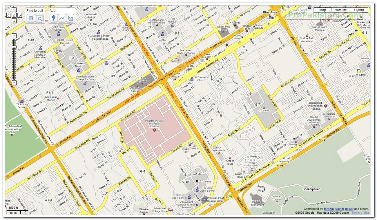
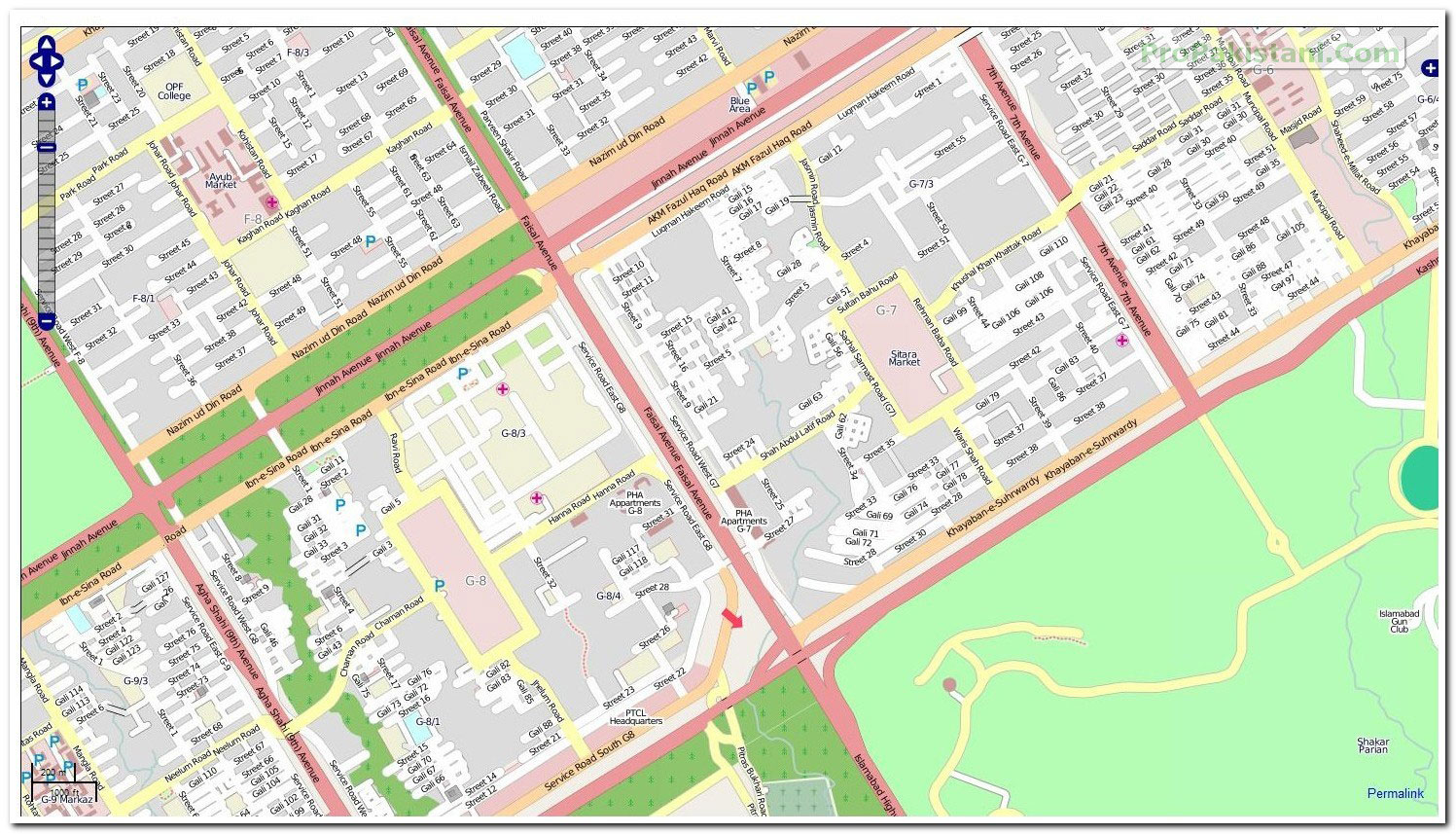
A comparison between the two (PIMS – Jinnah Avenue Interchange, Islamabad) :
Google MapMaker (Click on Image to View Full Size):
OpenStreetMap (Click on Image to View Full Size):
The level of detail as seen in the above pictures is quite satisfactory for pre-departure route planning.
Garmin Maps (Provided by http://pkmaps.freeforums.org/)
A bunch of what I can assume are GPS enthusiasts have worked hard to develop these Garmin compatible maps. Using free software available over the Internet, they have worked tirelessly to create maps for Islamabad, Lahore, Karachi, Peshawar and Wah Cantt. Indexed (means address searchable) versions are also available. The forum encourages open source map creation and does not allow discussion about cracking/unlocking premium maps available for the region.
Using maps provided by these angels, I have been able to install a perfectly working Garmin Mobile XT. The GPS chip in my Nokia E71 is of course not the greatest, and I am able to lock my location in a minimum of 13m radius, which is of course very negotiable.
A-GPS (Assisted GPS), which primarily works by locating your position roughly by comparing your cell site on the cellular network to an existing databese of these cells/towers and thus triangulate you, is of course of hardly any use. The maps developed by these chaps provide a very good detail and make navigation for an unfamiliar person at least easy (of course the address in hand would be 3rd house on the right, after the second turn under the Pine Tree).
The setup demonstrated below using a Nokia E71 and Garmin Mobile XT.
Garmin’s software was of course cracked using a keygen, but the maps provided by pkmaps are free to distribute. The onboard GPS has provided me continuously with even 8m lock. The pictures above demonstrate a drive from my home in Rawalpindi to Jinnah Super Market in Islamabad. The maps were of course not up to date, but will provide a relief to somebody new in the city. I am working on improving the Rawalpindi section of the twin city maps, and with even more volunteers we can create a very very detailed navigation map.
Naqsha.net
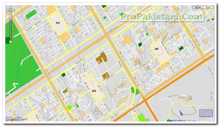
This was Pakistan’s first interactive map website. They provide two different online versions of their maps. One uses overlayed layers on Google Maps while the interactive maps utilize Adobe SVG Viewer to provide very good street level maps of all major cities of the country. The interactive maps also allow a user to plan a route quite easily. The same intersection is shown in Naqsha.net’s hybrid viewer below :
The best thing is that they provide excellent routing capabilities and the fastest or shortest distance calculations it does are indeed the ones anybody would use keeping either criteria in his/her mind.
Naqsha.net also provides maps for Garmin devices, and many people have utilized their maps.
The map has street level detail of major Pakistani cities and all major national highways. Streets are labeled and searchable for Islamabad, Lahore and some parts of Karachi. In addition there are close to 40,000 POIs such as fuel/CNG stations, banks, ATMs, hospitals, restaurants (categorised), hotels, shops, etc. Most POIs have address and phone number information available as well. Units equipped with FM transmitters and Bluetooth allow hands free dialing from the unit and are able to integrate with the vehicles’s audio system as well.
The current base unit, Garmin Nuvi 200w, retails for Rs. 29,750. If you are in Lahore, visit the display centre at Tracking World (Pvt) Ltd. For people in Islamabad units are on display at Hi Volts (F-8 Markaz) and Illusions (F-7 Markaz). You may also call at 042-111-22-66-66 for details.
Trakker Group
The in car SatNav provided by Trakker has extensive maps for Karachi District. The very small number of customers who have used their service are extremely satisfied with their product as it has very good routing capabilities. The problem remains the maps being limited to Karachi as of now. The system provided with them has DVD playback and other benefits as well but is very costly.
Get the latest news, tech updates, telecom insights, and business stories wherever you prefer.
Add ProPakistani to Preferred Sources and see more of our stories in Google Search and Top Stories.