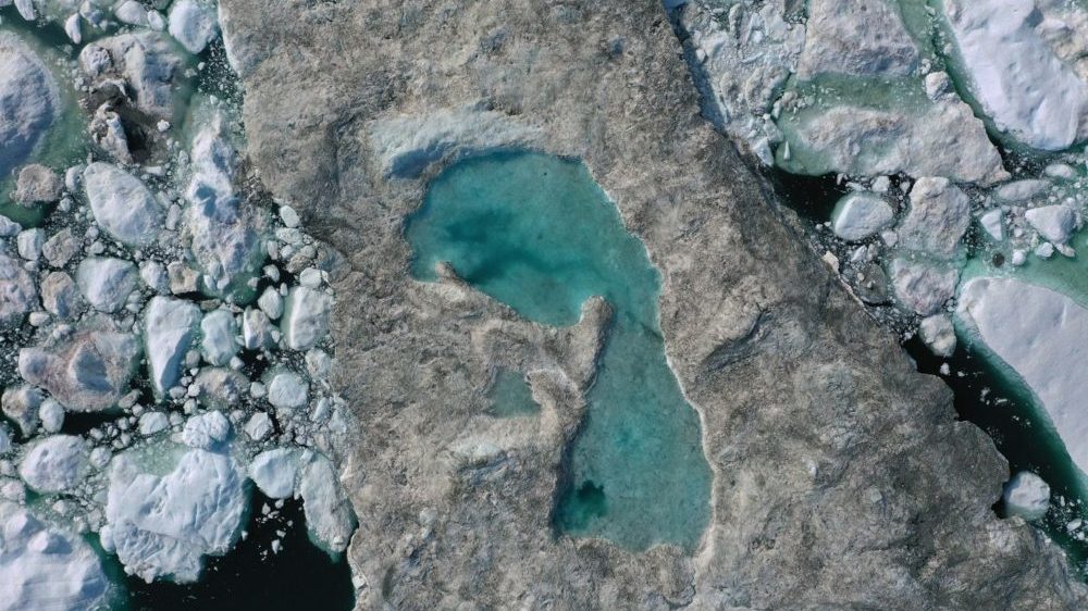
When you think of Greenland, ice covered, harsh and forbidding landscape comes to mind, not pockets of ice, melt ponds and streams transformed into raging rivers and almost certainly no wildfires.
Today, Greenland looks exactly like that, according to images posted on social media, researchers on the ground and information from satellites.
Earlier this week, an extraordinary melt event started on the Greenland ice sheet, and there are indications that over 60% of the extensive ice cover has seen visible surface melting, including higher elevations that rarely see temperatures climb above 0 degrees C.
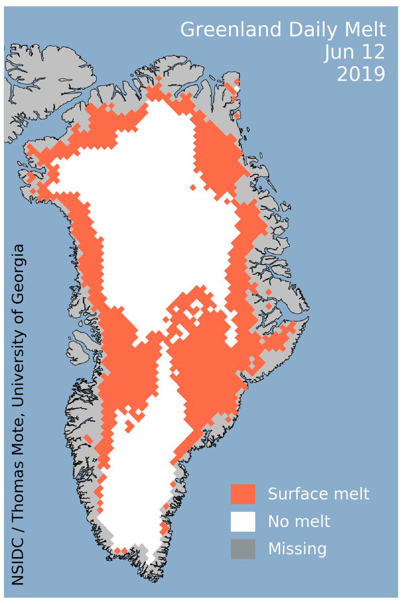
31st July 2012 was the previous largest melt day in Greenland, with over 60% of the ice sheet seeing at least 1 millimeter of melt at the surface, and over 10 billion tons of ice lost to the ocean. This data comes from the Polar Portal, a website run by Danish polar research institutions, and the National Snow and Ice Data Center.
Another significant melt day could be next Thursday before temperatures drop again.
According to climate researcher Ruth Mottram, affiliated with the Danish Meteorological Institute, the ice sheet sent 197 billion tons of water gushing into the Atlantic Ocean during July.
The #Greenland #icesheet starts August as it ended July – 11 Gigatonnes lost on 1st: highest daily total of the #melt season so far
Melt season should ramp down over the month but forecast shows warm period continuing next few dayshttps://t.co/R2dc4Kkjgl pic.twitter.com/D1g7gD1kVx
— Ruth Mottram (@ruth_mottram) August 2, 2019
In one-month, this is enough to increase global sea levels by 0.5 millimeters, or 0.02 inches, said Martin Stendel, a researcher with the institute.
This increase might seem insignificant, but every rise in sea-levels enables a bigger launch-pad for storms to more readily flood coastal infrastructure, such as New York’s subway system, parts of which were flooded during Hurricane Sandy in 2012. Think of a basketball game being played in a court with a floor which is gradually rising, making it easier for even shorter players to dunk the ball.
“This is the year Greenland is contributing most to sea-level rise,” said climate scientist Marco Tedesco at Columbia University.
High Temperatures
Due to a large area of high pressure all over Greenland — the same weather system that led to extreme heat in Europe last week — temperatures in Greenland have been recorded up to 15 to 30 degrees above average this week.
According to Christopher Shuman, a glaciologist at the University of Maryland-Baltimore County and NASA Goddard Space Flight Center, the thermometer crossed the above freezing mark for over 11 hours on Tuesday at Summit Station, which at 10,551 feet is situated at the highest point in Greenland and rarely sees temperatures above freezing.
Comparison With 2012 Event
The current melt event is being compared to record high temperatures and melt events that took place in Greenland in 2012. While the amount of surface melt during the 2012 event may have bigger than the 2019 one so far, Shuman discovered that Summit Station experienced the warmth that was bigger “in both magnitude and duration” during the 2019 event.
This is a roaring glacial melt, under the bridge to Kangerlussiauq, Greenland where it's 22C today and Danish officials say 12 billions tons of ice melted in 24 hours, yesterday. pic.twitter.com/Rl2odG4xWj
— Laurie Garrett (@Laurie_Garrett) August 1, 2019
The temperature only remained above freezing about half as long in 2012, and the peak temperature reached 34.02 degrees this year, whereas it only hit 33.73 in 2012. However, in the 2012 extreme event, 97% of the ice surface experienced melting.
Thomas Mote, a professor of geography at the University of Georgia, says,
Like 2012, this melt event reached the highest elevations of the ice sheet, which is highly unusual. “Both our satellite observations and the ground-based observations from Summit indicated melt on Tuesday. The event itself was unusual that the warm air mass came from the east, and appears to be a part of the air mass that caused the record-breaking heat wave in Europe. Most of our extreme melt days on the Greenland ice sheet are associated with warm air masses moving from the west and south. I cannot recall an instance where we saw such extensive melt associated with an air mass coming from Northern Europe.
Wildfires in Greenland
The heat, coupled with below-average rain in parts of Greenland, has even led to wildfires along Greenland’s non-ice-covered western fringes. Satellite imagery and photos were taken from the ground confirm fires burning in treeless areas, burning mossy wetlands that are vulnerable to fires when dry. These fires can burn into peatlands, releasing greenhouse gases buried ages ago through the decomposition of organic matter.
Studies have shown that ice melt periods like the one in 2012 usually happen about every 250 years, so the fact that another one is happening only a few years later could be a sign of how climate change is escalating everything.
According to DMI’s Mottram, the short-term, extreme melt event is a sign of climate change’s increasing influence on the Arctic.
“So yes it’s the weather but it shows that in spite of internal variability the background signal of a warming climate is still ‘winning’,” she said via a Twitter message. She said that state-of-the-art climate computer models have been unable to simulate events like this, which hampers scientists’ ability to accurately predict Greenland ice melt and, therefore, future sea-level rise.
Stay Connected with ProPakistani
Get the latest news and stories wherever you prefer.
Add ProPakistani to Preferred Sources and see more of our stories in Google Search and Top Stories.


Global Warming Is Already Arrived at EARTH :
Ye Duniya Bus Jang K Qareeb hai : Sub Khatam Hoga Sub
Please dunya sy phly tu khtm hja
chotiye apna kam kar
Should have let Thanos snap…