Google has updated satellite imagery for Pakistan (and many other countries) to be visible in Google Earth and Google Maps. Google has said that these updated images will be made available to Google Maps Mobile and Google Map Maker very soon.
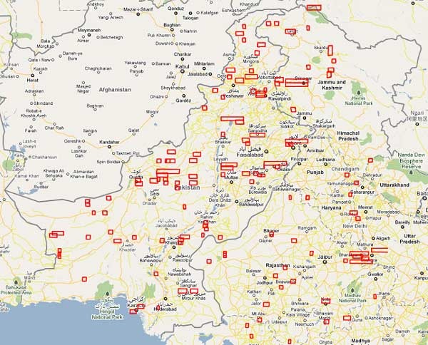
A large size of area received high resolution imagery update in Pakistan. See following screen-shot taken from Google Maps which marks the imagery updated areas for Pakistan in red rectangular.
Via Geography.PK










have you noticed google shows WHOLE of kashmir as a part of india? this was done by india as per below
http://www.boundscheck.com/tech-updates/notice-to-google/1757/
We pakistanis never could fight it back. may be you can start awareness of this and have this corrected as per UN accepted map.
Yes it is because the screenshot is taken from Google Maps India domain (http://maps.google.co.in/) while if you see the international domain at http://maps.google.com then you can see the UN boundaries defined. It is basically the same diplomatic stuff where international companies have to obey or favor local governments to setup their business. Similarly if you see Google Maps China (http://ditu.google.com/) you will see similar stuff for Arunachal Pradesh between India and China.
valuable information.
thanx
Excellent. This will make my life quite easy :)
Why? Do you deliver pizzas across cities?
Bs yar business hai… Do you need one???
^^nice :D
Google nay sirf kismair ko he nai gilgit baltistan k be kuch cities ko india ma shamil kar deya ha.. hum to kasmir ko india ka hesa nai samjta gilgit ko ku samja gay. wake up all pakistanies its time to do some thing……
We have a lame Govt. who dont have anything better to do beside creating problems for peoples, Now look at that Map which dont even show the reality, and Govt. is just sitting on their Asses !
Great News! i hope that google will sooner or later work on street view in Pakistan which can help many businesses aside entertaining us.
I remember someone on mapping team telling that Google does not have satellites so they buy commercial images from satellite companies. And because of interest in Afghan war and all the drone strikes in Pakistan more companies were taking high resolution pictures of Pakistan. That is why there is now higher resolution here compared with five years ago Not because Google payed extra for high resolution.
It’s sad to see that kashmeer is shown part of india!
Can Pro Pakistani use its forum to correct the anomaly in Google Maps where a huge chunk of Northern Pakistan is being wrongfully shown as part of India?
It is a serious matter & people should not joke during such situations.
IT Analyst of Pakistan should work together to delete all the sensitive images of Pakistan from Google Maps & should do something to prevent same with a tracking mechanism which can delete such images before anybody reviews, copies or publishes them anywhere else.
I remember the blocking of Indian FBI site for weeks. Well done guys & do the same with much more intellectuality to prove our expertize in this field.
Nothing is impossible except bringing someone back to life after death which can only be done by Almighty Allah SWT.
Will comment soon on this soon.
So kay raho gay to kia kia hoga aur kb tak soowo gay akhir jagna parega