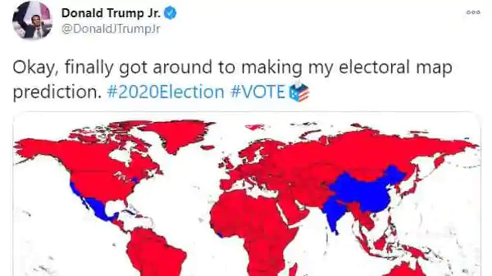
As the United States moved to elect its new President on November 3, Donald Trump Jr., the youngest son of President Trump, shared a world map engulfed with ‘red wave.’
Taking to Twitter on Election Day eve, Trump Jr. wrote:
Okay, finally got around to making my electoral map prediction. #2020Election #VOTE pic.twitter.com/STmDSuQTMb
— Donald Trump Jr. (@DonaldJTrumpJr) November 3, 2020
His motive was to show that the world supports his father’s re-election in the Oval Office. However, the tweet went viral for other reasons.
Trump Jr. made more than one comical errors in the map. He confused India with Iran, showed the Caspian Sea, Black Sea, Azov Sea, Aral Sea, and Antarctica as countries, while many other Asian countries as water bodies.
Huge turn out in Antarctica but nothing is for certain. Despite most voters in this area being penguins, things are rarely this black and white. https://t.co/Ra29V3ShD0
— Michael Fry (@BigDirtyFry) November 3, 2020
https://twitter.com/EmpTigerstar/status/1323687609361682436
https://twitter.com/notlivingmas/status/1323689839867428865
The predominantly red world map showed India (probably in confusion with Iran), and some other nations in blue meant that they would vote for the Democrat candidate, Joe Biden.
https://twitter.com/thucydiplease/status/1323649660343316480
The fun started when Indian netizens realized that the entire Kashmir region has actually been shown as part of Pakistan. Trump’s map showed India in blue, while Jammu and Kashmir in red along with Pakistan, depicting support for Donald Trump.
The tweet left Indian Twitterati in a frenzy as they criticized Trump Jr over ‘wrong’ depiction of geographical boundaries.
https://twitter.com/GarbageApe/status/1323636201644040199?s=20
https://twitter.com/mumbaiactor_/status/1323868727352324097
Modi is not going to be happy seeing that you removed kashmir from India. Bhakts aww do you still support Trump? ☺️
— 🇵🇸 پربھا 🏳️🌈 برابها (@deepsealioness) November 3, 2020
Some politicians also weighed in. Omar Abdullah, the former Jammu, and Kashmir Chief Minister wrote:
So much for the friendship with Trump Senior. Junior has placed India firmly with @JoeBiden & @KamalaHarris though interestingly Jr. believes J&K & the NorthEast go against the rest of India & will vote Trump. Someone needs to take his colouring pencils away. https://t.co/AqVyX4ixdl
— Omar Abdullah (@OmarAbdullah) November 3, 2020
Congress leader, Shashi Tharoor, took a dig at the Modi government and ridiculed the Prime Minister’s bromance with Trump.
The price of Namo’s bromance: Kashmir and the North East cut off from the rest of India. So much for the crores spent on obsequious serenading stadium events!
On the flip side, Pakistani Twitter celebrated it as a victory, especially after renowned comedian Jeremy McLellan’s tweet.
Thank you, Donald Trump Jr, for recognizing Jammu and Kashmir as part of Pakistan 🇵🇰 https://t.co/boHZhK5ivy
— Jeremy McLellan (@JeremyMcLellan) November 3, 2020
Note that this is the second time when Pakistan’s new political map has gained international recognition. Last week, Saudi Arabia had issued a celebratory banknote of 20 Riyal, showing Kashmir as part of Pakistan.
Finally Trump Admin recognized Kashmir as Part of Pakistan.
— Bad-Ass Patriot (@USBoy2014) November 3, 2020
Even he used solid line for separate kashmir from india. While used dotted line between Kashmir and Pakistan. 😄😄
— Unlimited_xs (@diff_of_opinion) November 3, 2020
Stay Connected with ProPakistani
Get the latest news and stories wherever you prefer.
Add ProPakistani to Preferred Sources and see more of our stories in Google Search and Top Stories.


True : Kashmir (Part of Pakistan) (Aj Kal Hamesha)
may be media persons are so dumb they cannot even how to view a map. Did you see boundaries of the countries. Gilgit & kashmir is shown as a separate country. How stupid is this media.