Seeing Earth from above reminds you how tiny we really are. The world’s mountains and oceans pale in comparison to the empty space that surrounds us.
While humanity may appear quite insignificant when viewing the globe from above, the borders that divide us can actually become clearer than ever. We can finally see them as the symbols of political and economic divide as clear as can be.
Below are a few instances where astronauts on the International Space Station (ISS) have been able to point their cameras toward the earth and create striking images of the world’s borders that, at times, say much about the countries they separate.
Pakistan / India
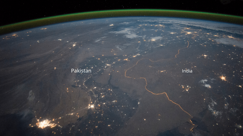
The Pakistan-India border is one of the few international boundaries evident at night because of illumination from bright security lights. 2,000 kilometers of the India-Pakistan border is floodlit and thousands of troops are permanently posted along at it.
Known as the Radcliffe Line, the border is one of the most heavily militarized in the world and has a fence running its entire distance.
South Korea / North Korea / China
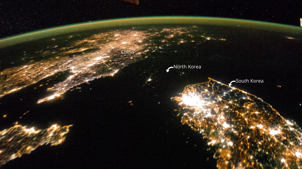
This image shows us a startling visualization of the widespread poverty that is reported to affect the majority of North Korea’s 25 million citizens.
North Korea has long had problems supplying enough electricity, and the bright lights of South Korea and China straddling the darkness of the North is eye-opening.
The only sign of life is the faint glow coming from the country’s capital, Pyongyang, whose light emissions are equal to those coming from the smaller towns in the South.
Occupied Palestine (Israel) / Egypt
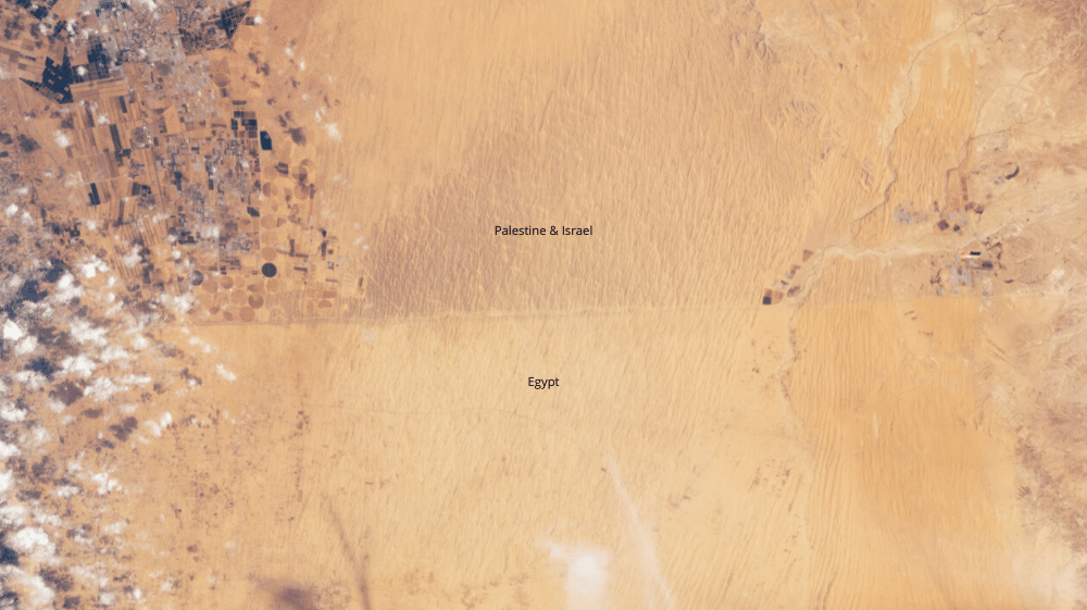
The Egypt- Occupied Palestine (Israel) boundary is highlighted by the soil choices of the countries’ agriculture industries. It’s visible, but only just. The different colors of the land are the result of the trampling of humans and their livestock. On the north side, Israel (Palestine) has fields rich with crops, but neighboring Egypt’s landscape is much emptier. A dirt track also helps to define the border.
East Germany / West Germany
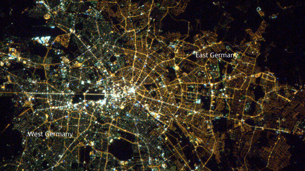
Over 30 years after the fall of the Berlin Wall, the separation between the eastern and western halves of Germany is still evident in Berlin at night. The yellow lights in the eastern part appear yellow, while the lights in the western part are a bit greener. This is a result of preferences for more environmentally friendly forms of lighting in the western part of the city.
Haiti / Dominican Republic
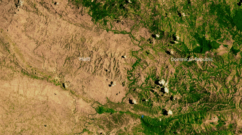
There is no mistaking the border between Haiti and the Dominican Republic. In this 2002 satellite image, the Dominican Republic on the right is far greener. This is the result of deforestation in Haiti.
Mexico / USA
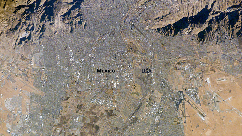
This image shows USA and Mexico separated by both the Rio Grande and a wall. Both are heavily developed, with the respective exceptions of Franklin Mountain State Park on the top right and land near Puerto de Anapra top left.
Iraq / Iran
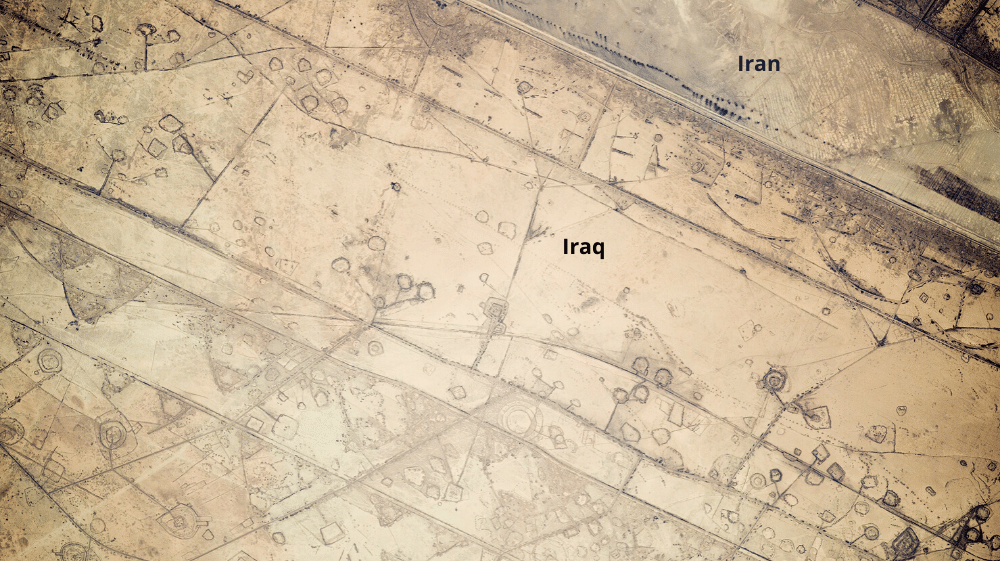
This 12-mile stretch of border between Iraq and Iran near the Persian Gulf is outlined by the installment of circular gun emplacements, connecting roads, and land fortifications that run parallel to the boundary.
Astronauts on the ISS first thought they were seeing oil-pad installations, but the strategic location of these formations made it clear that these were patterns of military fortifications.
China / Kazakhstan
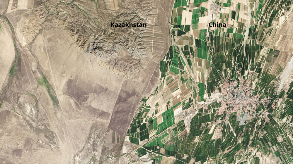
The green land in China is a striking contrast to Kazakhstan’s arid landscape in the west. Just over 11% of China’s land is arable, meaning farmers will use just about any space they can to grow crops to feed the country’s 1.3 billion people. Only 0.03% of Kazakhstan’s land is devoted to permanent agriculture, and it plays a small part in the country’s economy. The country has a few industrial-sized farms dotted throughout, but the land along the border with China is sparsely used.
Brazil / Bolivia
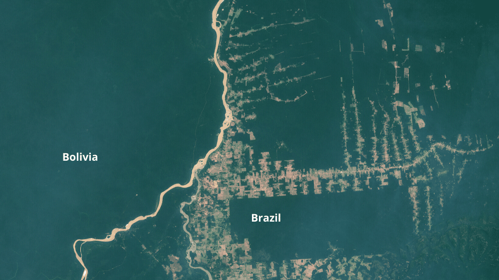
The Abuna river runs from near the top of the image outlining the northern border of Bolivia with Brazil. It meets the Madeira river to form the northernmost border of Bolivia, while the Manora river comes up from the south at the same river confluence, marking the eastern border of Bolivia.
Stay Connected with ProPakistani
Get the latest news, tech updates, telecom insights, and business stories wherever you prefer.
Add ProPakistani to Preferred Sources and see more of our stories in Google Search and Top Stories.


KARACHI VS LAHORE Ka Bhi Dhika Dete
I see what you did there B)… The “Occupied Palestine (Israel)”… I liked it :D